The First Printed Map of Hungary: the Tabula Hungarie 1528

Tabula Hungarie 1528

The Tabula Hungariae or Lazarus Map is the first surviving printed map of Hungary, probably made by the Hungarian Deacon Lazarus before 1528. The map, which is unique in its printing technique, was inscribed on the UNESCO World Heritage List on June 19, 2007. The only map of the medieval Kingdom of Hungary after the Battle of Mohács exists today in a single copy.

The area near Szolnok

The map shows the areas in the south of the country occupied by the Turks in different colors. Since it shows only the southern areas outside the border, its purpose may have been to prepare against the Turks and to show the system of fortifications. The detail of the settlements depicted is remarkable for the fact that some of them disappeared during the battles with the Turks and the period of Ottoman occupation.

Cardinal Bakócz Tamás
Cardinal Bakócz Tamás – the master of life and death in ecclesiastical and secular circles, who almost became pope – had many secretaries. They were university graduates, their names were written down. Now, you know that Deacon Lazarus (Lázár deák) was not a secretary, he was a simple scribe, what we would call today a high school graduate, so they didn’t record his surname or his date of birth. He produced the Tabula Hungarie, a map that proved to be far superior to the best maps of the time.
The Peasant War of Dózsa in 1514 in Hungary
Deacon Lazarus traveled all over the country on horseback with an armed escort to carry out his measurements. His employer could only have been Bakócz. The journey took several years and could not have been an easy task. He was caught up in the Dózsa peasant uprising and arrived in Mohács at the wrong time. Deák Lazarus’ numerous drawings and notes – lost over time – were sent to Vienna, where a Latinist university professor, Georg Tannstetter, compiled them and gave them to his colleague Petrus Apianus, who also printed astronomical and geographical maps.
Georg Tannstetter 1482-1535
The map covers the territory of the medieval Kingdom of Hungary, including the Balkan tributary provinces. The distance between each place and the circles on the map can be measured on the scale of miles at the bottom. Another interesting feature of the map is that the Balkan region has been squeezed to fit the ornate inscription and coat of arms of the Kingdom of Hungary. In the coat of arms of King Ferdinand I, we can recognize the coat of arms of Albrecht Dürer.
The printer: Petrus Apianus 1495-1552
The map is at a scale of about 1: 1 200 000 and measures 783×548 mm. In addition to Hungary, it also covers Croatia and parts of Serbia, Bosnia and Herzegovina, and Dalmatia. It extends as far west as Vienna and north and east to the Carpathians. The work of this Deacon Lazarus is amazing. His geometric knowledge deserves a special salute. About 1400 geographical names are written in their original form. Of these, 1270 are the names of settlements, 356 of which are in the territory of present-day Hungary. Several settlements were depopulated and ceased to exist during the Ottoman period.
The southern frontier of Hungary, the first part of the 16th century

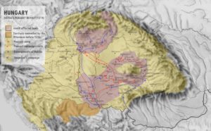
In medieval Hungary, from the second half of the 16th century, the southern border defense system – the construction of which became increasingly urgent due to the Ottoman-Turkish armies intending to attack the heart of Europe – was formed by two chains of fortifications running parallel to each other for about 100 kilometers. The first, mostly outside the borders of the Kingdom of Hungary, stretched from the border of Walachia to the Adriatic Sea, in territories conquered from the fallen Balkan states.

The correct position of the map (Source: Qorilla)

The outer line of defense followed the line of the Lower Danube from Szörényvár to Nándorfehérvár (now Belgrade), and from there it ran along the Száva River through the castles of the Srebrenica Banat. From here it curved in a great arc towards the Bosna River valley, reaching the Adriatic coast via Banja Luka, Jajca and Knin, Klis (now Klis), and Skardona (now Skradin). Behind this line of defense lay the second line of defense, which ran from Temesvár to Nándorfehérvár, followed by a chain of smaller fortresses in the Szerémség, partly along the Száva River, and then, following the valley of the Una River, the fortifications reached the Adriatic Sea at Zengg. The strongest point of this defense system was Nándorfehérvár, while the least fortified part was the southern border of Transylvania.

The Csepel Island of the Danube River near Buda

Older historical events are marked by diagrams, battle scenes (e.g. at the site of the Battle of Mohács), and inscriptions, while the area of the Turkish invasion of 1526 is marked by a series of dots. At the bottom, there are descriptions of the country in Latin and German. We can read the following text on it:

The Bánát Region of Hungary in the South

“Here a pious Christian can see how the Turkish Emperor, by the divine decree, conquered Bosnia, Rác-land, Hungary and Bulgaria, the Vendland, Serbia, and Dalmatia in a very short time.

All this is shown by the red color, the yellow color still represents the Christians whom the Almighty God is keeping under Your protection. Everything inside the dotted line was destroyed by the Turks after they won the battle in 1526″.

The text on the map

“The Hungarians have ruled this country for 600 years, but now the Turks have also invaded it, so just as a man must die and perish, so must the nation in time”.

The Lázár-deák memorial coin, made by Ugray György
Many copies of the original print were made, and a color woodcut can be found in the collection of the Széchenyi Library in Budapest. Several copies of the original edition of the map were made until 1552, none of which have survived. After 1552, however, maps of Hungary were also produced by copying the original Lazarus map under the titles “Tabula Hungariae” and “Nova descriptio totius Hungariae”.
Wolfgang Lazius’s great map from 1552, the “Tabula Hungariae”
The 1528 woodcut was produced in a small number of copies. These and later copies were all lost in the storms of history so that later researchers knew the original map only from descriptions. Only one copy was unexpectedly found in the early 1880s. This valuable document was bought by the book collector Count Apponyi Sándor in 1882.
The map of Mathias Zündt 1567, the “Nova descriptio totius Hungariae”
Sources: Naptármesék and Hungarian Wikipedia
Galambóc (Golubac) Castle on the Lázarus Map

Dear Readers, I can only make this content available through small donations or by selling my books or T-shirts: 

Please,  feel free to support me with a coffee here:

You can check out my books on Amazon or Draft2Digital, they are available in hardcover, paperback, or ebook:

https://www.amazon.com/dp/198020490X or at https://books2read.com/b/boYd81

My books "33 Castles, Battles, Legends" and "The Ring of Kékkő Castle"
My books “33 Castles, Battles, Legends” and “The Ring of Kékkő Castle”

My work can also be followed and supported on Patreon: Become a Patron!http://Become a Patron!

Become a Patron!

                                                                                                                              [wpedon id=”9140″]

Hussar shield designs on my T-shirts, available:
https://hungarianottomanwars.myspreadshop.com/all
Visit:https://hungarianottomanwars.myspreadshop.com/all